2024 PRESIDENTIAL GENERAL ELECTION
2024 Garfield County unofficial results
2024 Presidential General Election unofficial results from ballots cast in Garfield County are published below.Colorado statewide results
2024 Presidential General Election results statewide2024 Presidential General Election results Garfield County
Voter turnout
Unofficial report – 12:24 pm, 11.6.24Ballots cast     29,900
Active Voters     38,786
Percentage
2024 Presidential General Election unofficial results
Garfield County results only
Boards and commission meetings
NEWS
Ballots are mailed…all ballot dropboxes are open!
The Clerk & Recorder mailed out the 2024 General Election ballots October 11! All 24/7 ballot dropboxes are open to receive ballots. Ballots can be returned by mail, 24/7 dropboxes or at any of the vote centers. Your ballot must be received in our office by 7 p.m. on Election Day, November 5, 2024. Remember, postmarks do not count.
Request for Concept Plans period has ended
The Board of County Commissioners of Garfield County, Colorado, owner, and operator of the Rifle Garfield County Airport (RIL) issued a Request for Concept Plans on August 27, 2024, from which one proposal was submitted by the October 23, 2024, 2 p.m. deadline. The sole purpose and intent of this process was to make available airport land for aeronautical use in an open and fair manner to all interested aviation users.
Full documentation on the Rifle Garfield County Airport Request for Concept Plans is available currently.
The Rifle Garfield County Airport has land that is suitable for development on the west and east sides of the main apron. The land west of the main apron, between Taxiway A2 and A3, will be evaluated under the 2025 Airport Master Plan, which will evaluate land use and development alternatives. The land east of the main apron, around Taxiway B4 and B5, shown in the graphic below, is ready for development and is the subject of this Request for Concept Plans.
According to the current airport layout plan, the land east of the main apron, along Taxiway B4 and future Taxiway B5, is available for aircraft design groups II and III. Additional information regarding these development areas is included in this document.
Vacant land along Taxiway B4, including parcels A-2, A-3, A-4, A-5, A-6, A-8, and A-9, have been leased or are in the conceptual plan or development plan phase. The County expects to see development for a variety of aviation uses, including corporate hangars, FBO operations, private hangars, and ramp space on these parcels.
Highway 82 closed for season over Independence Pass
Mind Springs Health detox facility reports success
Sun glare safety closures on eastbound I-70 near Idaho Springs
SPEAR coordinates Hydrocodone bust in Glenwood Canyon
Beat the flues by getting your vaccine
Sam Carver named new Rifle Garfield County Airport director
Garfield County emergency alerts
Garfield County Property Search
Use our online portal to access property records in Garfield County, via a database records search or our map search.
Calendar
Services
Emergency alertsPublic Surplus Auction
Winter maintenance
Emergency response
Emergency Management9-1-1 Emergency Communication
Fire and smoke information
Burn permit onlineGarfield County Fire Code
Fire restriction stages
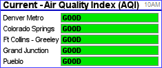
Air quality statewide |
AQI Index for Colorado River Valley reports Garfield County air quality Garfield County air management-| |